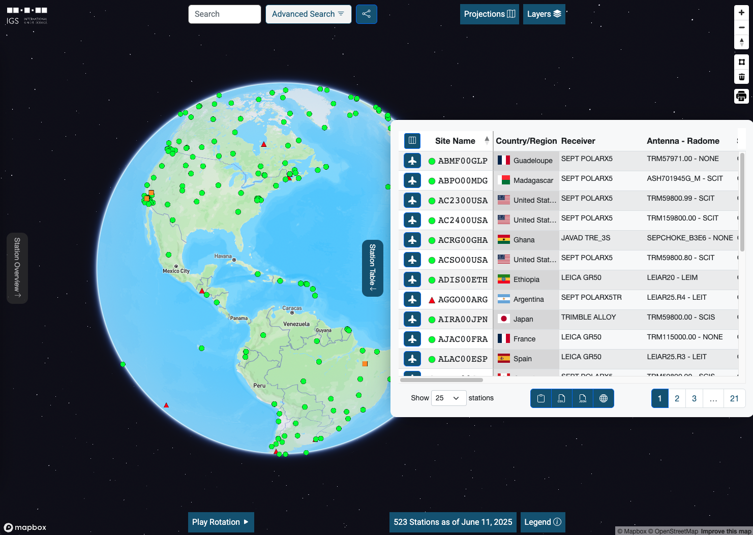
Tools

7 items in "Tools" category

RSS Feed
IGS Network Map

IGS Network Map

Brian Kohan
The International GNSS Service (IGS) has ensured open access, high-quality GNSS data products since 1994. These products enable access to the definitive global reference frame for scientific, educational, and commercial applications – a tremendous benefit to the public, and key support element for …
LA District Finder

LA District Finder

How did your districts change? Every 10 years we count all of our neighbors in the decennial census. The results are used to redraw legislative boundaries from Capitol Hill down to our most local levels of city government. The goal is to rebalance the number of residents in each district to maintain …
LA-HOP Tracker

LA-HOP Tracker

Brian Kohan
Los Angeles County has a Homeless Outreach Portal called LA-HOP. Anyone can submit requests through this portal that include location, time, and a description of the person experiencing homelessness and what needs they have. These requests are triaged by the Service Planning Area (SPA) coordinators …
Mission Clock

Mission Clock

Brian Kohan
This is a javascript browser app that implements a mission clock. The clock settings are entirely URL parameter based so links to different mission clocks defined by epoch and style can be bookmarked.
Homeless Count Data

Homeless Count Data

Brian Kohan
This interactive map visualizes data from the 2021 community led Point-in-Time (PIT) count of unsheltered homeless adults in Hollywood as well as data from the (2016-2020) Los Angeles Homeless Services Authority (LAHSA) PIT counts. Additional 2021 neighborhood counts of Mid City, Eagle Rock and …
AGAPE

AGAPE

Brian Kohan
Atmospheric Grid Analysis & Profile Extraction (AGAPE) When low earth orbit (LEO) satellites receive GPS signals that have first traveled though the atmosphere we refer to this as an atmospheric radio occultation. They occur in that brief window when a LEO satellite sets or rises behind the earth …
Automatic Precise Point Positioning Service (APPS)

Automatic Precise Point Positioning Service (APPS)

Brian Kohan
This is a webservice that uses GipsyX software that we have developed to run precise point positioning on GNSS RINEX data. With enough good data we achieve static positioning at ~5 millimeter precision and kinematic positioning for receivers on mobile platforms at ~5 centimeter precision. This …